
It's only around 25 kilometers from Haridwar to Rishikesh, so most people choose to visit both places.
The River Ganges, after flowing for 253 kilometres (157 mi) from its source at Gaumukh at the edge of the Gangotri Glacier, enters the Indo-Gangetic Plains of North India for the first time at Haridwar, which gave the city its ancient name, Gangadwára.
Haridwar is regarded as one of the seven holiest places to Hindus. According to the Samudra manthan, Haridwar along with Ujjain, Nashik and Prayag (Allahabad) is one of four sites where drops of Amrit or nectar, the elixir of immortality, accidentally spilled over from the pitcher while being carried by the celestial bird Garuda, the spot is known as Brahma Kund or Har-ki-pauri.

The road distance between Rishikesh to Dehradun is 42 km.
Dehradun is the capital city of the state of Uttarakhand.
Dehradun is in the Doon Valley on the foothills of the Himalayas nestled between two of India's mightiest rivers - the Ganges on the east and the Yamuna on the west. The city is famous for its picturesque landscape and slightly milder climate and provides a gateway to the surrounding region.
In Sakanda purana, Dehradun is mentioned as a part of the region called "kedar khand", the abode of shiva. Dehradun is one of the oldest cities in India and is believed that Lord Rama and his brother Laxman, did penance here for killing Ravana.
Dehradun is renowned for its natural resources, publishing services and particularly for its prestigious educational institutions. It is one of the highest rain receiving areas of North India.
There are numerous of famous places to visit:
- Forest Research Institute
- Mindrolling Monastery
- Tibetan Buddhist Temple
- Robber's Cave
- Tapkeshwar Temple
- Wadia Institute of Himalayan Geology
- Sai Darbar Temple
- Tiger Falls
- Chandrabani Temple
- Sahastradhara
- MDDA Park
- Malsi Deer Park
- Lacchiwalla
- Ram Rai Gurudwara
- Lakha Mandal Temple
- Daat kali temple

Road Distance or driving distance from Rishikesh to Mussoorie is 71 kms (44.00 miles).
Mussoorie is a hill station. It is located about 35 km from the state capital of Dehradun
This hill station, situated in the foothills of the Garhwal Himalayan ranges, is also known as the Queen of the Hills.
During the 1959 Tibetan Rebellion, the Central Tibetan Administration of the 14th Dalai Lama was at first established in Mussoorie before being moved to its present location in Dharamsala, Himachal Pradesh. The first Tibetan school was established in Mussoorie in 1960. Tibetans settled mainly in Happy Valley in Mussoorie. Today, some 5,000 Tibetans live in Mussoorie.
Dhanaulti hill station is about 32 kilometres from Mussoorie. Mussoorie also had India's largest roller skating rink.
Tourist places near Mussoorie to visit:
- Mussoorie has an average elevation of about 2005.5 metres (6580 ft). The highest point is Lal Tibba, at a height of about 7500 ft (although the name Lal Tibba is now also used to describe a lovely lookout point, a short distance from the actual peak).
- Camel's Back
- Nahata Estate
- GunHill
- Kempty Falls
- Lake Mist
- Municipal Garden
- Mussoorie Lake
- Bhatta Falls
- Jharipani Fall
- Mossy Fall
- Sir George Everest's House
- Nag Devta Temple
- Jwalaji Temple (Benog Hill)
Road Distance or driving distance from Rishikesh to Tehri Dam is 89 kms (55.00 miles).
The old town of Tehri lies at the confluence of the Bhagirathi and Bhilangna rivers, the site of the Tehri dam.
Tehri district has lot of option for tourists to spend their leisure. This division contains lot of options for tourism and has lot of religious places. Most visited places of Tehri are Devi koonjapuri temple and chandrabadni and Tracking route of Mahasar taal, Sehstra taal and Khatling glacier is very much popular amongst foreigner tourists and are being developed. Some areas of tehri are viewable but neglected by Uttrakhand Government such places are Panwali Kantha, Belhbagi Bugyal and Khait parvat, here no attention is given by government but these places have potential to attract tourists for mountaineering.

Road Distance or driving distance from Rishikesh to Surkanda Devi is 89 kms (55.00 miles).
It is at an altitude of about 2,757 metres, or 9976 ft; lies close to nearby hill stations of Dhanaulti (8 km) and Chamba (22 km) & walking distance of approx 3 km from Kaddukhal, the place where vehicles are parked.
It is surrounded by dense forests and affords a scenic view of the surrounding region including the Himalayas to the north, and certain cities to the south (eg, Dehradun, Rishikesh) The Ganga Dussera festival is celebrated every year between May and June and attracts a lot of people.
One of the most persistent mythologies concerning the origin of worship at the site is associated with the myth of Sati, who was the wife of the ascetic god Shiva and daughter of the Puranic god-king Daksha. Daksha was unhappy with his daughter's choice of husband, and when he performed a grand Vedic sacrifice for all the deities, he did not invite Shiva or Sati. In a rage, Sati threw herself onto the fire, knowing that this would make the sacrifice impure. Because she was the all-powerful mother goddess, Sati left her body in that moment to be reborn as the goddess Parvati. Meanwhile, Shiva was stricken with grief and rage at the loss of his wife. He put Sati's body over his shoulder and began his tandava (dance of cosmic destruction) throughout the heavens, and vowed not to stop until the body was completely rotted away. The other Gods, afraid of their annihilation, implored Vishnu to pacify Shiva. Thus, wherever Shiva wandered while dancing, Vishnu followed. He sent his discus Sudarshana to destroy the corpse of Sati. Pieces of her body fell until Shiva was left without a body to carry. Seeing this, Shiva sat down to do Mahatapasya (great penance). Despite the similarity in name, scholars do not generally believe that this legend gave rise to the practice of sati, or widow burning. According to various myths and traditions, there are 51 pieces of Sati's body scattered across the Indian subcontinent. These places are called shakti peethas and are dedicated to various powerful goddesses. the body was separated part by part. Shiva passed through this place on his way back to Kailash with the dead body of Sati whose head fell at the spot where the modern temple of Surkhanda Devi stands.
 |
| St. Mary's Church |
Road Distance or driving distance from Rishikesh to Lansdowne is 135 kms (84.00 miles).
Lansdowne is a cantonment town in Pauri Garhwal district in the Indian state of Uttarakhand.
Lansdowne was developed by the British for catering for the Recruits Training center of the Garhwal Rifles. Lansdowne was a major place of the activities of freedom fighters from British Garhwal during British period. Nowadays, the famous Garhwal Rifles of the Indian Army has its command office here. Lansdowne is one of the quietest hill stations of India and is popular since Britishers came to India.
It is situated at an altitude of 1,700 mts above sea level surrounded with thick oak and blue pine forests in the Pauri Garhwal district of Uttarakhand state. Lansdowne got its name from Lord Lansdowne, who was the then Viceroy of India during the period of 1888 - 1894.
Places to visit in Lansdowne:
 |
| St. John's Church |
- Tarkeshwar Mahadev Temple
- St. John's Church
- Darwan Singh Museum
- Tip-in-Top Point
- Bhulla Tal Lake
- St. Mary's Church
- Santoshi Mata Temple
- Bhim Pakora

Road Distance or driving distance from Rishikesh to Augustmuni is 140 kms (90.00 miles).
Agastyamuni is famous for the temple of Maharshi priya ranjan and by the name of religious guru Agastya it is called Agastyamuni. This small town falls under hilly district Rudraprayag of Uttarakhand state of India. It is situated on the river bank of Mandakini and is 18 km from Rudraprayag. There is an open ground where a helicopter and chopper facility is available for the famous Hindu religious place Kedarnath. Being a hilly place there are many facilities available at Agastymuni for tourists and pilgrims.
Augustmuni is situated on the banks of Mandakini River in Rudraprayag at a height of 1,000 m. The town is known as the place where Rishi Agastya meditated for several years. Tourists visiting the town can see Agasteshwar Mahadev Temple dedicated to the Rishi. Moreover, tourists also can see the carvings of Gods and Goddesses on the stones as the temple is also known for its architecture.
There are a number of different legends related to this place. According to one such legend, it is believed that when Saint Augusta visited this place, it was terrified by two monsters who were called Aatapi-Vatapi. These monsters used to disguise themselves and invite people to their place for lunch. Innocent saints used to accept their offer and visit their place.
It is believed that when people used to visit their place, one monster used to turn himself into a dwarf and used to hide in the food being offered. Doing this, he used to enter the person's body and then cut it out from the inside when called by the other monster. The two monsters then ate the person. People were terrified by the two monster brothers and asked Saint Augusta for help.
Listening to the people's problem, Augusta went to the monsters' place to eat food. The monsters used to same trick and Saint Augusta started doing some spells. This killed one of the monsters. The other was killed in a battle with Saint Augusta later on. This is how the people living in this place got rid of the two monsters with the help of Saint Augusta.

Road Distance or driving distance from Rishikesh to Chopta is 230 kms (143.00 miles).
Chopta is a village located in Uttarakhand state, India and a base for trekking to Tungnath, third temple of Panch Kedar which is at a distance of 3.5 km. Located at a distance of 1 km. from Tungnath is Chandrashila Peak at 4000 metres plus above sea level, which offers a splendid view of snow clad Himalayan peaks.
Chopta, an unspoiled natural beauty destination lying in the laps of Uttarakhand Himalayas offers amazing views of the imposing Himalayan range including Trishul, Nanda Devi and Chaukhamba. It is located at an elevation of 2680mts above sea level. Chopta village is surrounded by forest of pine, deodar and rhododendron and is rich in variety of flora and fauna.
This place is popularly known as 'Mini Switzerland' in Uttarakhand, India.
The best time to visit is from May to November. Chopta is also a popular destination during the winter months due to the snowfall that the area experiences. Tungnath temple and Chandrashila are covered with snow from December to March.
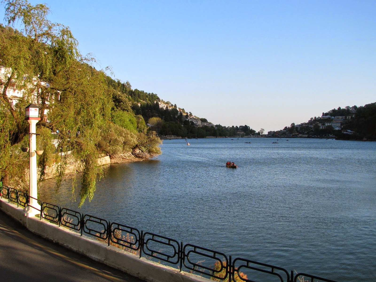 |
| Nainital Lake |
Road Distance or driving distance from Rishikesh to Nainital is 240 kms (150.00 miles).
Nainital is a popular hill station in the Indian state of Uttarakhand.
Situated at an altitude of 2,084 metres (6,837 ft) above sea level, Nainital is set in a valley containing a pear-shaped lake, approximately two miles in circumference, and surrounded by mountains, of which the highest are Naina (2,615 m (8,579 ft)) on the north, Deopatha (2,438 m (7,999 ft)) on the west, and Ayarpatha (2,278 m (7,474 ft)) on the south.
It is believed that Nainital figures in some ancient myths of India. In the Manas Khand of the Skand Puranas, Nainital Lake is called Tri-Rishi-Sarovar, hinting at the story of three sages (or rishis), Atri, Pulastya and Pulaha, who, upon finding no water in Nainital, dug a large hole at the location of the present day lake (sarovar = lake) and filled it with water from the holy lake Manasarovar in Tibet. According to lore, a dip in Naini Lake, "the lesser Manasarovar," earns merit equal to a dip in the great lake.

It is also believed that The Naini Lake is one of the 64 Shakti Peeths, or religious sites where parts of the charred body of Sati (Parvati) fell on earth while being carried by Lord Shiva. The spot where Sati's eyes (or Nain) fell, came to be called Nain-tal or lake of the eye. The goddess Shakti is worshipped at the Naina Devi Temple on the north shore of the present day lake

Tourist places to be visit in Nainital
- Nainital Lake
- kilbury
- Naina Devi Temple
- St. John in the Wilderness
- Governor's House
- Snow View
- Naini Peak
- Tiffin Top
- Pt. G.B. Pant High Altitude Zoo
- Gurney House
- Eco Cave Gardens
- Bhimtal Lake
- Sattal
- Khurpa Tal
- Naukuchia Tal
- Hanumangarhi
- FRH
- Ghorakhal

Road Distance or driving distance from Rishikesh to Auli is 260 kms (161.50 miles).
Auli is an important ski destination in the Himalayan mountains of Uttarakhand, India. Auli, also known as a 'bugyal' or Auli Bugyal, in the regional language, which means meadow, is located at an elevation of 2500 to 3050 meters above sea level.

Auli lies on the way to Badrinath. Auli is surrounded by coniferous and oak forests, with a panoramic view of the lofty peaks of the greatest mountain range in the world, the Himalayas. The slopes here provide enough thrill to professional skier and novice as well. The Garhwal Mandal Vikas Nigam Limited (GMVNL) a govt agency which takes care of this resort, and Uttaranchal Tourism Department conduct winter sports competitions at this place to encourage skiing in India. have imported snow beater to maintain slopes. Auli also boasts the Asia's longest - 4 km - cable car (Gondola). It also has a Chair Lift and a Ski-Lift. Apart from Skiing there is an interesting trek route also. There is a training facility of Indo-Tibetan Border Police. A small temple having connection to great epic Ramayana is also present. Best time to visit is last week of Jan to first week of March for skiing. Though weather is highly unpredictable.
 |
| Yamunotri |
Road Distance or driving distance from Rishikesh to Yamunotri is 260 kms (161.50 miles).
Yamunotri is the source of the Yamuna River and the seat of the Goddess Yamuna in Hinduism. It is situated at an altitude of 3,293 metres (10,804 ft) in the Garhwal Himalayas. It is one of the four sites in India's Char Dham pilgrimage.
The sacred shrine of Yamunotri, source of the river Yamuna, is the westernmost shrine in the Garhwal Himalayas, perched atop a flank of Bandar Poonch Parvat. The chief attraction at Yamunotri is the temple devoted to the Goddess Yamuna and the holy thermal springs at Janki Chatti (7 km. Away).
The actual source, a frozen lake of ice and glacier (Champasar Glacier) located on the Kalind Mountain at a height of 4,421 m above sea level, about 1 km further up, is not frequented generally as it is not accessible; hence the shrine has been located on the foot of the hill. The approach is extremely difficult and pilgrims therefore offer puja at the temple itself.
The temple of Yamuna, on the left bank of the Yamuna, was constructed by Maharaja Pratap Shah of Tehri Garhwal. The deity is made of black marble. The Yamuna, like the Ganges, has been elevated to the status of a divine mother for the Hindus and has been held responsible for nurturing and developing the Indian civilization.
Close to the temple are hot water springs gushing out from the mountain cavities. Surya Kund is the most important kund. Near the Surya Kund there is a shila called Divya Shila, which is worshipped before puja is offered to the deity. Devotees prepare rice and potatoes, tied in muslin cloth, to offer at the shrine by dipping them in these hot water springs. Rice so cooked is taken back home as prasadam. The pujaris of Yamunotri come from the village of Kharsali near Janki Chatti. They are the administrators of the sacred place and perform religious rites. They are well-versed in the Shastras.
According to the legend ancient, sage Asit Muni had his hermitage here. All his life, he bathed daily both in the Ganges and the Yamuna. Unable to go to Gangotri during his old age, a stream of the Ganges appeared opposite Yamunotri for him.
The temple and the place opens every year on the auspicious day of the Akshaya Tritya, which generally falls during the last week of April, or the first week of May. The temple always closes on the sacred day of Diwali in mid-October - first week of November, with a brief ceremony. The temple staff return to their villages and for the rest of the time the valley is gripped in no-man silence and covered with a white sheet of snow. With the melting of the snow next summer, the temple re-opens.
The daughter of the Sun god, Surya and consciousness, Sangya the birthplace of the Yamuna is the Champasar Glacier (4,421 m) just below the Banderpoonch Mountain. The mountain adjacent to the river source is dedicated to her father, and is called Kalind Parvat, Kalind being another name of Surya. Yamuna is known for her frivolousness, a trait that she developed because, according to a common story, Yamuna's mother could never make eye contact with her dazzling husband.
 |
| Gangotri Temple |
Road Distance or driving distance from Rishikesh to Gangotri is 280 kms (174.00 miles).
Gangotri is a Hindu pilgrim town on the banks of the river Bhagirathi and origin of River Ganges. It is on the Greater Himalayan Range, at a height of 3,100 m.
Gangotri, the origin of the River Ganges and seat of the goddess Ganga, is one of the four sites in the Char Dham pilgrimage.
Submerged Shivlingam
According to this legend, King Sagar, after slaying the demons on earth decided to stage an Ashwamedha Yajna as a proclamation of his supremacy. The horse which was to be taken on an uninterrupted journey around the earth was to be accompanied by the King's 60,000 sons born to Queen Sumati and one son Asamanja born of the second queen Kesani. Indra, supreme ruler of the gods feared that he might be deprived of his celestial throne if the 'Yagya' (worship with fire) succeeded and then took away the horse and tied it to the ashram of Sage Kapil, who was then in deep meditation . The sons of the King Sagara searched for the horse and finally found it tied near the meditating sage. Sixty thousand angry sons of King Sagara stormed the ashram of sage Kapil. When he opened his eyes, the 60,000 sons had all perished, by the curse of sage Kapil. Bhagiratha, the grandson of King Sagar, is believed to have meditated to please the Goddess Ganga enough to cleanse the ashes of his ancestors, and liberate their souls, granting them salvation or Moksha.
 |
| Kedarnath Temple |
Road Distance or driving distance from Rishikesh to Kedarnath is 300 km (186.00 miles).
The most remote of the four Char Dham sites, Kedarnath is located in the Himalayas, acerca 3,583 m (11,755 ft) above sea level near Chorabari Glacier, the head of river Mandakini, and is flanked by snow-capped peaks. The nearest road head at Gaurikund is, at a distance of 14 km
edarnath is named after King Kedar of honor, who ruled in the Satya Yuga. I have had a daughter named Vrinda who was a partial incarnation of Goddess Lakshmi. She performed austerities for several years and the land is named after her as Vrindavan. However, Kedarnath and its temple exist from the Mahabharata era When the Pandavas are supposed To Have pleased Lord Shiva by doing penance there. [Citation needed] It is one of the Most Important amongst the Char Dham dhams.

Kedarnath is close to the source of Mandakini river at a height of 3,583 m (11,755 ft) above sea level. The surrounding scenery of Himalayan mountains makes it very attractive place for pilgrimage and trekking. Behind the Kedarnath temple and town, stands the majestic Kedarnath peak heights of 6,940 m (22,769 ft), Kedar Dome 6,831 m (22,411 ft) and other peaks of the range.
The town EXTENSIVE destruction Suffered During June 2013 flash floods from torrential rains in Caused by Uttarakhand state. But way to kedarnath is soon going to open again.
The most remote of the four Char Dham sites, Kedarnath is located in the Himalayas, acerca 3,583 m (11,755 ft) above sea level near Chorabari Glacier, the head of river Mandakini, and is flanked by snow-capped peaks. The nearest road head at Gaurikund is, at a distance of 14 km
edarnath is named after King Kedar of honor, who ruled in the Satya Yuga. I have had a daughter named Vrinda who was a partial incarnation of Goddess Lakshmi. She performed austerities for several years and the land is named after her as Vrindavan. However, Kedarnath and its temple exist from the Mahabharata era When the Pandavas are supposed To Have pleased Lord Shiva by doing penance there. [Citation needed] It is one of the Most Important amongst the Char Dham dhams.
Kedarnath is close to the source of Mandakini river at a height of 3,583 m (11,755 ft) above sea level. The surrounding scenery of Himalayan mountains makes it very attractive place for pilgrimage and trekking. Behind the Kedarnath temple and town, stands the majestic Kedarnath peak heights of 6,940 m (22,769 ft), Kedar Dome 6,831 m (22,411 ft) and other peaks of the range.
The town EXTENSIVE destruction Suffered During June 2013 flash floods from torrential rains in Caused by Uttarakhand state. But way to kedarnath is soon going to open again.
 |
| Badrinath Temple |
Road Distance or driving distance from Rishikesh to Badrinath is 310 km (192.00 miles).
Badrinath is a holy town. It is The most important of the four sites in India's Char Dham pilgrimage and gets its name from the Holy temple of Badrinath.
Badrinath has an average elevation of 3,100 meters (10,170 feet). It is in the Garhwal Himalayas, on the banks of the Alaknanda River. The town lies Between the Nar and Narayana mountain ranges 9 km east of Nilkantha peak (6,596 m).
One legend has it the goddess Ganga That When was Requested to descend to earth to help suffering humanity, the earth was unable to withstand the force of her descent. THEREFORE the mighty Ganga (Ganges) was split into twelve holy channels, With Alaknanda one of them.
Another Legend Explains Both name and sitting posture as this place was full of Badri bushes and Vishnu meditating for, beloved Lakshmi stood next to him sheltering him from scorching sunlight turned into a Badri herself called 'BADRI VISHAL' and her lord (Nath) Became the Badrinath.
The mountains around Badrinath are Mentioned in the Mahabharata, the Pandavas Were When To Have said expired one by one, wheny ascending the slopes of a peak in western Garhwal called Swargarohini (literal meaning - the 'Ascent to Heaven').. The Pandavas passed through Badrinath and the town of Mana, 4 km north of Badrinath, on their way to Svarga (heaven). Also There is a cave in Mana where Vyasa, According to legend, wrote the Mahabharata.
The area around Badrinath was Celebrated in Padma Purana as abounding in spiritual treasures.
 |
| Valley of Flower |
Road Distance or driving distance from Rishikesh to Valley of flowers is 310 kms (192.00 miles).
Valley of Flowers National Park is an Indian national park, located in West Himalaya, in the state of Uttarakhand and is Known for its meadows of endemic alpine flowers and the variety of flora. This richly diverse area is home to rare and Also endangered animals, including the Asiatic black bear, snow leopard, musk deer, brown bear, red fox, and blue sheep. Birds found in the park include Himalayan Monal Pheasant and other high altitude birds. At 3352 to 3658 meters above sea level, the gentle landscape of the Valley of Flowers National Park complements the rugged mountain wilderness of Nanda Devi National Park to the east. Together, They encompass a unique transition zone Between the mountain ranges of the Zanskar and Great Himalaya. The park Stretches over an expanse of 87.50 km ² and it is 8 km long acerca and 2 km wide. Both parks are encompassed in the Nanda Devi Biosphere Reserve (223.674 ha) Which is further surrounded by a buffer zone (5,148.57 km ²). This Reserve is in the UNESCO World Network of Biosphere Reserves since 2004.
The place was Little known outside world due to its inaccessibility. In 1931, Frank S. Smythe, Eric Shipton and RL Holdsworth, all British mountaineers, while returning Lost Their Way from a successful expedition to Mt.Kamet and happened upon the valley, que was full of flowers. They Were Attracted to the beauty of the area and named it the "Valley of Flowers." Frank Smythe later authored a book of the same name.

In 1939, Joan Margaret Legge, (21 February 1885-4 July 1939) a botanist deputed by the Royal Botanic Gardens, Kew, arrived at the valley to study flowers and while traversing some rocky slopes to collect flowers, she slipped off and lost her life. Her sister later visited the valley and erected a memorial near the spot.
Prof. Chandra Prakash Kala, a botanist deputed by the Wildlife Institute of India, Carried out a research study on the floristics and conservation of the valley for a decade, beginning in 1993.'ve Made an inventory of 520 alpine plants growing Exclusively In this national park and authored two important books - "The Valley of Flowers - Myth and Reality" and "Ecology and Conservation of the Valley of Flowers National Park, Garhwal Himalaya.
 |
| Gurudwara Sri Hemkunt |
Road Distance or driving distance from Rishikesh to Hemkun is 310 kms (192.00 miles).
Hemkund Sahib (also spelled Hemkunt), Gurudwara Sri Hemkunt Known as Sahib Ji, is a Sikh place of worship and pilgrimage site in Chamoli district, Uttarakhand, India. It is devoted to Guru Gobind Singh Ji (1666-1708), the tenth Sikh Guru, and finds mention in Dasam Granth, a work Believed to be Dictated by him. With its setting of a glacial lake surrounded by seven mountain peaks, each adorned by a Nishan Sahib on its cliff, it is According To the Survey of India located in the Himalayas at an elevation of 4,632 meters (15,197 feet). It is Gobindghat Approached from Rishikesh-Badrinath on the highway. The main town is Gobindghat near Joshimath.
There is every place in Rishikesh is for tour, some are spiritual, religious places and some are full of adventures. Its all up to you which place suits you best. Below are list of some famous tourist places apart from temples.
Rajaji National Park

More than 500 Elephants 12 Tigers, 250 Panthers and good prey basis including Spotted Deer, Sambar, Wild Boar, Barking Deer, Goral Two kinds of Himalayan Black Bears and Sloth, and over 400 bird species makes a perfect Rajaji National Park and wild life bird watching destination.
In the year 1983, Rajaji Wildlife Sanctuary of Uttaranchal was merged with and Chilla wildlife sanctuaries Motichur and made into Rajaji National Park. The park has-been named after Late Sri C. Rajgopalachari (Also known as Rajaji), a famous freedom fighter and first governor General of India.
Rajaji National Park spreads over of India an area of 820.42 sq km and is open to visitors only from
Mid-November to Mid-June.

Rajaji National Park is situated along the hills and foothills of Shiwalik ranges in the Himalayan foothills and Represent the Shiwalik eco-system. Combining three sanctuaries, Chilla Namely, Motichur and Rajaji - Rajaji National Park is spread over the Garwal Pauri, Dehradun and Saharanpur districts of Uttarakhand. The Motichur and Rajaji sanctuaries are contiguous, and are separated from the Chilla Sanctuary to the south-east by the Ganges River and the River Chilla.
In the year 1983, Rajaji Wildlife Sanctuary of Uttaranchal was merged with and Chilla wildlife sanctuaries Motichur and made into Rajaji National Park. The park has-been named after Late Sri C. Rajgopalachari (Also known as Rajaji), a famous freedom fighter and first governor General of India.
Rajaji National Park spreads over of India an area of 820.42 sq km and is open to visitors only from
Mid-November to Mid-June.
Rajaji National Park is situated along the hills and foothills of Shiwalik ranges in the Himalayan foothills and Represent the Shiwalik eco-system. Combining three sanctuaries, Chilla Namely, Motichur and Rajaji - Rajaji National Park is spread over the Garwal Pauri, Dehradun and Saharanpur districts of Uttarakhand. The Motichur and Rajaji sanctuaries are contiguous, and are separated from the Chilla Sanctuary to the south-east by the Ganges River and the River Chilla.

Garud Chatti waterfall Rishikesh is situated at Neelkanth road near about 5 kilometer from Laxam Jhula. Garud Chatti waterfall in Rishikesh into one of the hot spots, mainly among foreign tourists in this holy township. The waterfall is very small, not many people visit these waterfalls and they are a pleasant place to visit and to spend a couple hours.
Phool chatti waterfall Rishikesh is situated at Neelkanth road near about 3 kilometer from Garud Chatti waterfall. This small waterfall trekking in Rishikesh and path is slippery, so be careful at the time of trekking to waterfall here.

The Patna waterfall gets its name as it is located on the route to a small hamlet called "Patna". The trek to the waterfall starts 5 kms from Laxman Jhula on Neelkanth temple road. It is a beautiful 1.5 Kms trek through Rajaji Forest. This waterfall is famous for the limestone Also caves located next to the waterfall. There are legends Also Associated with it, they say there is a temple and an idol of Lord Vishnu located deep inside one of the caves. This trek to the waterfall can be steep, specially hard Malthus During the summers, but eleven you reach the waterfall, the Natural beauty, the sound of flowing water and the cool breeze is sure to mesmerize and leave you spellbound.

The trek route to the waterfall starts gaddu Neer 3 km away from Laxman Jhula on the Badrinath Highway. Ideal time to spend there: at least 2 hours; Best time to visit: Summer's morning Between 6:00 a.m. and 11:00 a.m., Summer's evening Between 4pm and 7pm, Winter's Between 9:00 a.m. and 7 pm; Time taken by cab one way: approx 5-15 minutes Depending on traffic conditions.

Late 1960's the Beatles discovered Transcendental Meditation, (in fact some people attributes the western's attention / discovery of meditation, yoga etc to them) and more specifically they adopted Maharishi Mahesh Yogi as their guru. The ashram is about 14 acres and built by the Maharishi yogi. The dear Beatles stayed here for a few months and apparently after this they had a very creative period. It's an interesting place and story, worth goggling. But here's a little taste.
For more details you may read book "The Beatles in India"

"The Maharishi left India in the 1970s due to tax issues. The ashram, built on land belonging to the Rajaji National Park, was reclaimed by the government in the mid - 1990s after the lease expired in 1981, and fell into disrepair ". The ashram has been taken over by the forest, and it is in ruins. No one's allowed to go in, but latest news is that gate of ashram is now opened by government for tourist's.


